
Santa Cruz topographic map
Click on the map to display elevation.
About this map
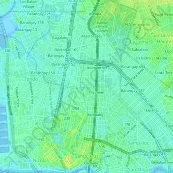
Name: Santa Cruz topographic map, elevation, terrain.
Average elevation: 8 m
Minimum elevation: -1 m
Maximum elevation: 26 m
Other topographic maps
Click on a map to view its topography, its elevation and its terrain.
Plaza de Roma
In 1901, with the start of American rule, the plaza was renamed Plaza McKinley, after U.S. President William McKinley, who authorized the colonization of the Philippines by the United States. The plaza was given its current name in 1961, following the elevation of Rufino Santos to the College of Cardinals of…
Average elevation: 7 m