
Pico Island topographic map
Interactive map
Click on the map to display elevation.
Pico Island
Pico Island (Ilha do Pico, Portuguese pronunciation: [ˈiʎɐ du ˈpiku]) is an island in the Central Group of the Portuguese Azores. The landscape features an eponymous volcano, Ponta do Pico, which is the highest mountain in Portugal, the Azores, and the highest elevation of the Mid-Atlantic Ridge. In the tradition of the Portuguese poet, Raul Brandão, Pico is referred to as the Ilha Preta ("Black Island"), for its black volcanic soils, which nourish its UNESCO-designated vineyards that once allowed the development of the island's economy. Pico is the second largest and, geologically speaking, the most recently formed island of the Azores, being around 300,000 years old.
About this map
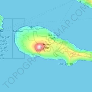
Name: Pico Island topographic map, elevation, terrain.
Location: Pico Island, Azores, Portugal (38.38207 -28.54190 38.56143 -28.02820)
Average elevation: 104 m
Minimum elevation: 0 m
Maximum elevation: 2,279 m
Other topographic maps
Click on a map to view its topography, its elevation and its terrain.
Santo António da Serra
The parish of Santo António da Serra, located in the interior of the southern coast of Madeira, pertains to the municipality of Machico, confronted in the north and east by the parish of Porto da Cruz, west by the municipality of Santa Cruz, and by extent 20 kilometres from Funchal, the regional capital. It…
Average elevation: 624 m
Parque do Bonito
Portugal > Santarém > Entroncamento > Nossa Senhora de Fátima
Average elevation: 50 m
Soutelinho do Monte
Portugal > Vila Real > Vila Pouca de Aguiar > Vreia de Bornes
Average elevation: 577 m
Mount Pico
Mount Pico (Portuguese: Montanha do Pico) is a currently dormant stratovolcano located on Pico Island, in the mid-Atlantic archipelago of the Azores. It is the highest mountain in Portugal, at 2,351 metres (7,713 ft) above sea level, and is one of the highest Atlantic mountains; it is more than twice the…
Average elevation: 1,694 m
Cidadelha de Jales
Portugal > Vila Real > Vila Pouca de Aguiar > Alfarela de Jales
Average elevation: 783 m