
Make a donation
Gear up for your next adventure:
As an Amazon Associate, this site earns from qualifying purchases at no extra cost to you.
Opal topographic map
Click on the map to display elevation.
Make a donation
Gear up for your next adventure:
As an Amazon Associate, this site earns from qualifying purchases at no extra cost to you.
Opal
Opal (formerly Fayettesville) is an unincorporated community and census-designated place (CDP) in Fauquier County, Virginia, United States. It is on U.S. Highway 15/U.S. Route 17 and U.S. Route 29, at an elevation of 449 feet (137 m). The population as of the 2010 census was 691.
Make a donation
Gear up for your next adventure:
As an Amazon Associate, this site earns from qualifying purchases at no extra cost to you.
About this map
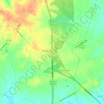
Name: Opal topographic map, elevation, terrain.
Location: Opal, Fauquier County, Virginia, United States (38.60087 -77.82062 38.64087 -77.78062)
Average elevation: 129 m
Minimum elevation: 108 m
Maximum elevation: 154 m
Make a donation
Gear up for your next adventure:
As an Amazon Associate, this site earns from qualifying purchases at no extra cost to you.
Other topographic maps
Click on a map to view its topography, its elevation and its terrain.
Make a donation
Gear up for your next adventure:
As an Amazon Associate, this site earns from qualifying purchases at no extra cost to you.
C.F. Phelps Wildlife Management Area
United States > Virginia > Fauquier County
Average elevation: 95 m
Make a donation
Gear up for your next adventure:
As an Amazon Associate, this site earns from qualifying purchases at no extra cost to you.