Geolocate

Avondale topographic map

Click on the map to display elevation.

About this map

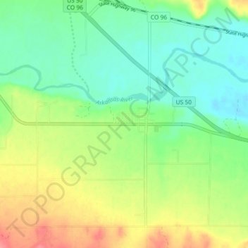
Name: Avondale topographic map, elevation, terrain.

Location: Avondale, Pueblo County, Colorado, 81022, United States (38.22377 -104.39563 38.24935 -104.32319)

Average elevation: 1,391 m

Minimum elevation: 1,364 m

Maximum elevation: 1,434 m

Other topographic maps

Click on a map to view its topography, its elevation and its terrain.

Colorado City

United States > Colorado > Pueblo County

Average elevation: 1,811 m

Taylor Park

United States > Colorado > Pueblo County

Average elevation: 1,846 m

Boone

United States > Colorado > Pueblo County

Average elevation: 1,371 m

Pueblo

United States > Colorado > Pueblo County > Pueblo

Average elevation: 1,509 m

Gear up for your next adventure:

🥾Hiking Leggings - Comfortable leggings for outdoor activities
🔦LED Flashlight - Powerful and long-lasting flashlight for camping and emergencies
🧴Waterproofing Spray - Restore the DWR coating on jackets and tents
🔨Vehicle Emergency Tool - Safety tool for remote road trips to trailheads
🥾Waterproof Hiking Boots - Boots keeping your feet dry in wet conditions

As an Amazon Associate, this site earns from qualifying purchases at no extra cost to you.