
Lichfield topographic map
Interactive map
Click on the map to display elevation.
About this map
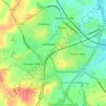
Name: Lichfield topographic map, elevation, terrain.
Location: Lichfield, Staffordshire, Angleterre, Royaume-Uni (52.65791 -1.86523 52.70326 -1.79271)
Average elevation: 91 m
Minimum elevation: 61 m
Maximum elevation: 140 m
Other topographic maps
Click on a map to view its topography, its elevation and its terrain.
Alrewas
Royaume-Uni > Angleterre > Staffordshire > Lichfield
Alrewas, Lichfield, Staffordshire, Angleterre, Royaume-Uni
Average elevation: 59 m