Geolocate

Seneca topographic map

Click on the map to display elevation.

About this map

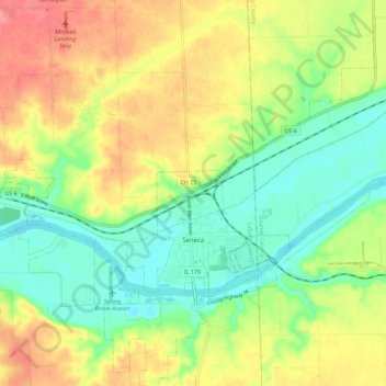
Name: Seneca topographic map, elevation, terrain.

Location: Seneca, LaSalle County, Illinois, United States (41.27854 -88.63794 41.36322 -88.52687)

Average elevation: 180 m

Minimum elevation: 145 m

Maximum elevation: 225 m

Other topographic maps

Click on a map to view its topography, its elevation and its terrain.

Wedron

United States > Illinois > LaSalle County

Average elevation: 179 m

Dayton

United States > Illinois > LaSalle County

Average elevation: 179 m

Hitt

United States > Illinois > LaSalle County > Ottawa

Average elevation: 174 m

Serena

United States > Illinois > LaSalle County

Average elevation: 192 m

Gear up for your next adventure:

🧦Hiking Liner Socks - Thin base layer to prevent friction and blisters
🧼Travel Hand Sanitizer - Keep hands clean when water is scarce
👖Convertible Hiking Pants - Zip-off legs to adapt to changing weather conditions
🔦LED Flashlight - Powerful and long-lasting flashlight for camping and emergencies
🥾Lightweight Hiking Shoes - Comfortable shoes for day hikes

As an Amazon Associate, this site earns from qualifying purchases at no extra cost to you.