Geolocate

Ulat topographic map

Click on the map to display elevation.

About this map
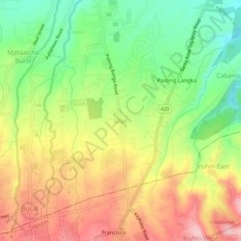
Name: Ulat topographic map, elevation, terrain.

Location: Ulat, Silang, Cavite, Calabarzon, 4118, Philippines (14.13538 120.96801 14.17538 121.00801)

Average elevation: 473 m

Minimum elevation: 377 m

Maximum elevation: 577 m

Other topographic maps

Click on a map to view its topography, its elevation and its terrain.
Carmen

Philippines > Cavite > Silang

Average elevation: 172 m

Carmen

Philippines > Cavite > Silang

Average elevation: 172 m

Carmen

Philippines > Cavite > Silang

Average elevation: 172 m

Gear up for your next adventure:

🔦LED Headtorch - Bright and durable light for night activities
👖Convertible Hiking Pants - Zip-off legs to adapt to changing weather conditions
🧰Survival Kit - Essential gear for emergencies in the wilderness
🥾Hiking Shorts - Breathable shorts suitable for summer hikes
🧥Waterproof Hiking Jacket - Protect yourself from rain and wind while hiking

As an Amazon Associate, this site earns from qualifying purchases at no extra cost to you.