Geolocate

Orlean topographic map

Click on the map to display elevation.

About this map

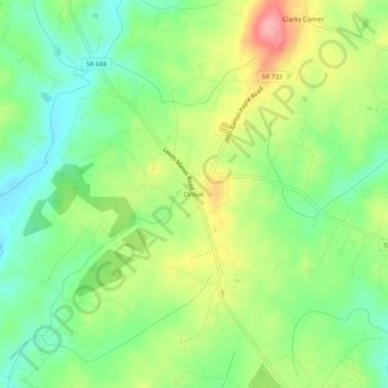
Name: Orlean topographic map, elevation, terrain.

Location: Orlean, Fauquier County, Virginia, 20128, United States (38.73262 -77.98388 38.77262 -77.94388)

Average elevation: 173 m

Minimum elevation: 126 m

Maximum elevation: 242 m

Other topographic maps

Click on a map to view its topography, its elevation and its terrain.

Bealeton

United States > Virginia > Fauquier County > Bealeton

Average elevation: 100 m

Marshall

United States > Virginia > Fauquier County

Average elevation: 189 m

New Baltimore

United States > Virginia > Fauquier County

Average elevation: 148 m

Rectortown

United States > Virginia > Fauquier County

Average elevation: 161 m

Upperville

United States > Virginia > Fauquier County

Average elevation: 172 m

Broad Run

United States > Virginia > Fauquier County > Broad Run

Average elevation: 164 m

Gear up for your next adventure:

🧥Waterproof Hiking Jacket - Protect yourself from rain and wind while hiking
🧶550 Survival Paracord - Versatile utility cord for emergency repairs and rigging
🧣Merino Neck Gaiter - Protects against wind, sun, and cold at high altitudes
🔋Lithium AA Batteries - Long-lasting power that performs in extreme cold
🧥Softshell Jacket - Windproof and breathable jacket for hiking

As an Amazon Associate, this site earns from qualifying purchases at no extra cost to you.