Make a donation
Gear up for your next adventure:
As an Amazon Associate, this site earns from qualifying purchases at no extra cost to you.
Chestnut Mountain topographic map
Click on the map to display elevation.
Make a donation
Gear up for your next adventure:
As an Amazon Associate, this site earns from qualifying purchases at no extra cost to you.
About this map
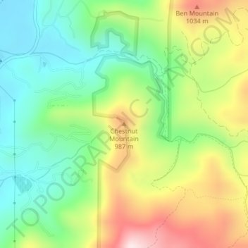
Name: Chestnut Mountain topographic map, elevation, terrain.
Average elevation: 834 m
Minimum elevation: 642 m
Maximum elevation: 1,134 m
Make a donation
Gear up for your next adventure:
As an Amazon Associate, this site earns from qualifying purchases at no extra cost to you.
Other topographic maps
Click on a map to view its topography, its elevation and its terrain.
Black Rock Mountain State Park
United States > Georgia > Rabun County > Mountain City
Average elevation: 833 m
Tallulah Gorge State Park
United States > Georgia > Rabun County > Tallulah Falls
Average elevation: 435 m
Make a donation
Gear up for your next adventure:
As an Amazon Associate, this site earns from qualifying purchases at no extra cost to you.
