Geolocate

Viola topographic map

Click on the map to display elevation.

About this map

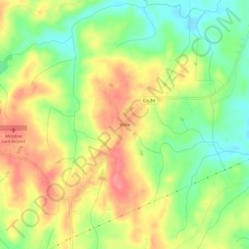
Name: Viola topographic map, elevation, terrain.

Location: Viola, Heard County, Georgia, United States (33.23484 -85.16883 33.27484 -85.12883)

Average elevation: 237 m

Minimum elevation: 195 m

Maximum elevation: 278 m

Other topographic maps

Click on a map to view its topography, its elevation and its terrain.

Corinth

United States > Georgia > Heard County

Average elevation: 233 m

Centralhatchee

United States > Georgia > Heard County

Average elevation: 252 m

Ephesus

United States > Georgia > Heard County

Average elevation: 360 m

Franklin

United States > Georgia > Heard County

Average elevation: 223 m

Gear up for your next adventure:

🩹Moleskin Blister Pads - Direct protection for painful foot pressure points
🪜Heavy Duty Carabiners - Multi-use clips for securing gear to your backpack
💧Hydration Pack - Hands-free hydration system for long hikes
🦌Outdoor Trail Camera - Monitor wildlife activity near your favorite spots
🧥Ultralight Puffy Jacket - Maximum warmth that packs down to the size of an orange

As an Amazon Associate, this site earns from qualifying purchases at no extra cost to you.