Geolocate

Mott Station topographic map

Click on the map to display elevation.

About this map

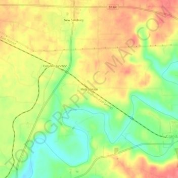
Name: Mott Station topographic map, elevation, terrain.

Location: Mott Station, Harrison County, Indiana, 47114, United States (38.27812 -86.11053 38.31812 -86.07053)

Average elevation: 214 m

Minimum elevation: 177 m

Maximum elevation: 245 m

Other topographic maps

Click on a map to view its topography, its elevation and its terrain.

Lanesville

United States > Indiana > Harrison County

Average elevation: 239 m

New Amsterdam

United States > Indiana > Harrison County

Average elevation: 151 m

New Middletown

United States > Indiana > Harrison County

Average elevation: 215 m

Crandall

United States > Indiana > Harrison County

Average elevation: 217 m

Laconia

United States > Indiana > Harrison County

Average elevation: 201 m

Gear up for your next adventure:

🌬️Windproof Camp Stove - Efficient cooking even on exposed mountain peaks
👟Trail Running Shoes - Agile footwear for fast-paced topographic exploration
🧣Merino Neck Gaiter - Protects against wind, sun, and cold at high altitudes
🪑Insulated Seat Pad - Protect your seat from cold rocks and wet logs
🛏️Camping Sleeping Mat - Comfortable mats for sleeping outdoors

As an Amazon Associate, this site earns from qualifying purchases at no extra cost to you.