Geolocate

Sunne topographic map

Click on the map to display elevation.

About this map

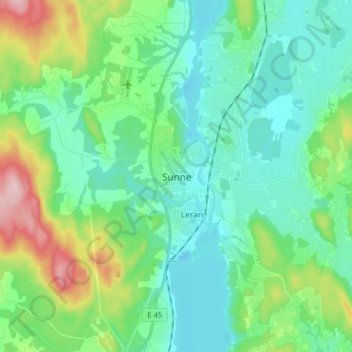
Name: Sunne topographic map, elevation, terrain.

Location: Sunne, Sunne kommun, Värmland County, 686 31, Sweden (59.80018 13.09548 59.88018 13.17548)

Average elevation: 110 m

Minimum elevation: 58 m

Maximum elevation: 276 m

Other topographic maps

Click on a map to view its topography, its elevation and its terrain.

Hammarö kommun

Sweden > Värmland County

Average elevation: 45 m

Sunne kommun

Sweden > Värmland County

Average elevation: 194 m

Hammarö kommun

Sweden > Värmland County

Average elevation: 45 m

Hagfors kommun

Sweden > Värmland County

Average elevation: 257 m

Kils kommun

Sweden > Värmland County

Average elevation: 104 m

Torsby kommun

Sweden > Värmland County

Average elevation: 356 m

Säffle kommun

Sweden > Värmland County

Average elevation: 89 m

Pottern

Sweden > Värmland County

Average elevation: 145 m

Karlstads kommun

Sweden > Värmland County

Average elevation: 109 m

Filipstads kommun

Sweden > Värmland County

Average elevation: 241 m

Storfors kommun

Sweden > Värmland County

Average elevation: 158 m

Gear up for your next adventure:

💧Filtered Water Bottle - Safe drinking water on the go
🔪Outdoor Multitool - Versatile tool for repairs and food prep in the wild
🔦LED Headlamp - Hands-free lighting for early morning starts or late finishes
🧥Softshell Jacket - Windproof and breathable jacket for hiking
💡LED Headlamp - Hands-free illumination for night hiking and camping

As an Amazon Associate, this site earns from qualifying purchases at no extra cost to you.