Geolocate

Lake Agco topographic map

Click on the map to display elevation.

About this map
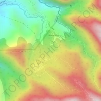
Name: Lake Agco topographic map, elevation, terrain.

Location: Lake Agco, Agco, Kidapawan, North Cotabato, Soccsksargen, 9400, Philippines (7.01725 125.22293 7.01765 125.22344)

Average elevation: 1,302 m

Minimum elevation: 966 m

Maximum elevation: 1,627 m

Other topographic maps

Click on a map to view its topography, its elevation and its terrain.
San Roque

Philippines > North Cotabato > Kidapawan

Average elevation: 87 m

Balabag

Philippines > North Cotabato > Kidapawan

Average elevation: 789 m

Indangan

Philippines > North Cotabato > Kidapawan

Average elevation: 504 m

Onica

Philippines > North Cotabato > Kidapawan

Average elevation: 85 m

Amas

Philippines > North Cotabato > Kidapawan

Average elevation: 96 m

Sikitan

Philippines > North Cotabato > Kidapawan

Average elevation: 129 m

Puasinda

Philippines > North Cotabato > Kidapawan

Average elevation: 89 m

Junction

Philippines > North Cotabato > Kidapawan

Average elevation: 102 m

Linangkob

Philippines > North Cotabato > Kidapawan

Average elevation: 190 m

Gear up for your next adventure:

🍽️Titanium Camping Spork - Ultralight and indestructible eating utensil
🥾Waterproof Hiking Boots - Boots keeping your feet dry in wet conditions
🧥Softshell Jacket - Windproof and breathable jacket for hiking
🧴Outdoor Sunscreen - High SPF protection for high-altitude UV exposure
☕Camping Coffee Maker - Brew fresh coffee anywhere on the topographic map

As an Amazon Associate, this site earns from qualifying purchases at no extra cost to you.