Geolocate

Junction topographic map

Click on the map to display elevation.

About this map

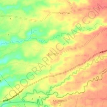
Name: Junction topographic map, elevation, terrain.

Location: Junction, Kidapawan, North Cotabato, Soccsksargen, Philippines (6.97087 124.98053 7.01087 125.02053)

Average elevation: 102 m

Minimum elevation: 63 m

Maximum elevation: 125 m

Other topographic maps

Click on a map to view its topography, its elevation and its terrain.

Lake Agco

Philippines > North Cotabato > Kidapawan

Average elevation: 1,302 m

Gear up for your next adventure:

🌬️Windproof Camp Stove - Efficient cooking even on exposed mountain peaks
🔭Compact Binoculars - Lightweight optics for scouting trails and wildlife
🧥Packable Rain Jacket - Breathable waterproof layer for unpredictable weather
🧤Insulated Winter Gloves - Heavy-duty protection for sub-zero Canadian adventures
💡LED Headlamp - Hands-free illumination for night hiking and camping

As an Amazon Associate, this site earns from qualifying purchases at no extra cost to you.