
Hesketh Bank topographic map
Click on the map to display elevation.
About this map
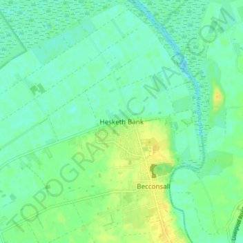
Name: Hesketh Bank topographic map, elevation, terrain.
Average elevation: 8 m
Minimum elevation: -1 m
Maximum elevation: 20 m
Other topographic maps
Click on a map to view its topography, its elevation and its terrain.
Bispham
United Kingdom > England > Lancashire > West Lancashire > Bispham Green
Average elevation: 26 m
Up Holland
United Kingdom > England > Lancashire > West Lancashire > Upholland
Average elevation: 89 m
Scarisbrick
United Kingdom > England > Lancashire > West Lancashire > Scarisbrick
Average elevation: 12 m
Bury Hey Wood
United Kingdom > England > Lancashire > West Lancashire > Appley Bridge > Robin Hood
Average elevation: 106 m
Bickerstaffe
United Kingdom > England > Lancashire > West Lancashire > Bickerstaffe
Average elevation: 51 m
Bury Hey Wood
United Kingdom > England > Lancashire > West Lancashire > Appley Bridge > Robin Hood
Average elevation: 106 m