Geolocate

6th district topographic map

Click on the map to display elevation.

About this map

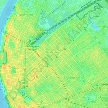
Name: 6th district topographic map, elevation, terrain.

Location: 6th district, Budapest, Central Hungary, Hungary (47.49755 19.05479 47.51856 19.08084)

Average elevation: 114 m

Minimum elevation: 100 m

Maximum elevation: 126 m

Other topographic maps

Click on a map to view its topography, its elevation and its terrain.

Danube

Hungary > Budapest

Average elevation: 114 m

Gellért Hill

Hungary > Budapest

Average elevation: 126 m

Ziggurat

Hungary > Budapest

Average elevation: 108 m

Csúcs-hegy

Hungary > Budapest

Average elevation: 261 m

Gellért Hill

Hungary > Budapest

Average elevation: 126 m

Tigers

Hungary > Budapest

Average elevation: 111 m

Danube

Hungary > Budapest

Average elevation: 125 m

Gear up for your next adventure:

🧦Hiking Socks - Moisture-wicking and comfortable socks for long hikes
🥤Collapsible Travel Cup - Saves space and weight in your mess kit
🧢Outdoor Visor - Breathable visor for sunny hikes
🛶Waterproof Dry Bags - Keep electronics and clothes dry during river crossings
💧Reusable Water Bottle - Durable water bottles for hydration on trails

As an Amazon Associate, this site earns from qualifying purchases at no extra cost to you.