Geolocate

Berden topographic map

Click on the map to display elevation.

About this map

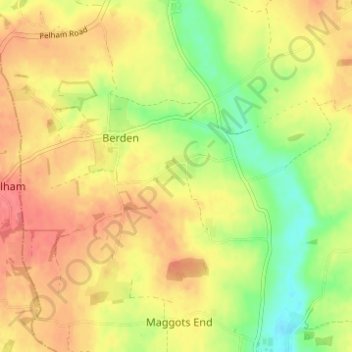
Name: Berden topographic map, elevation, terrain.

Location: Berden, Uttlesford, Essex, England, United Kingdom (51.92998 0.11471 51.95583 0.17632)

Average elevation: 104 m

Minimum elevation: 68 m

Maximum elevation: 131 m

Other topographic maps

Click on a map to view its topography, its elevation and its terrain.

Coles Green

United Kingdom > England > Essex > Uttlesford > Berden > Little London

Average elevation: 100 m

Gear up for your next adventure:

👟Trail Running Shoes - Agile footwear for fast-paced topographic exploration
🧰Survival Kit - Essential gear for emergencies in the wilderness
🔥Emergency Fire Starter - Reliable ignition source for all weather conditions
🦌Outdoor Trail Camera - Monitor wildlife activity near your favorite spots
👟Leg Gaiters - Keep debris, mud, and snow out of your boots

As an Amazon Associate, this site earns from qualifying purchases at no extra cost to you.