Geolocate

Dolomite topographic map

Click on the map to display elevation.

About this map

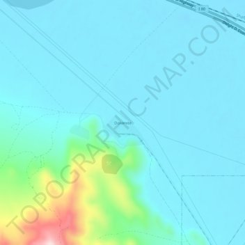
Name: Dolomite topographic map, elevation, terrain.

Location: Dolomite, Tooele County, Utah, United States (40.68313 -112.59586 40.72313 -112.55586)

Average elevation: 1,324 m

Minimum elevation: 1,278 m

Maximum elevation: 1,598 m

Other topographic maps

Click on a map to view its topography, its elevation and its terrain.

Grantsville

United States > Utah > Tooele County

Average elevation: 1,345 m

Vernon

United States > Utah > Tooele County

Average elevation: 1,679 m

Stansbury Park

United States > Utah > Tooele County > Lake Point

Average elevation: 1,318 m

Stockton

United States > Utah > Tooele County

Average elevation: 1,580 m

Lake Point

United States > Utah > Tooele County

John C. Frémont, a second lieutenant in the U.S. Army Corps of Topographical Engineers, was commissioned by the US Government to explore the Mexican territory west of the Louisiana Purchase with a special interest in the terrain and various routes that could link the Midwest to California. In the summer of…

Average elevation: 1,425 m

Wendover

United States > Utah > Tooele County

Average elevation: 1,325 m

Gear up for your next adventure:

🧣Evaporative Cooling Towel - Beat the heat during intense summer climbs
🕶️Polarized Sunglasses - Protect your eyes with durable polarized lenses
💧Collapsible Water Bottle - Space-saving water bottle for outdoor activities
🔭Outdoor Binoculars - Lightweight binoculars for birdwatching and hiking
🧢Sun Protection Cap - Breathable cap to protect from sun exposure

As an Amazon Associate, this site earns from qualifying purchases at no extra cost to you.