Geolocate

Ocean City topographic map

Click on the map to display elevation.

About this map

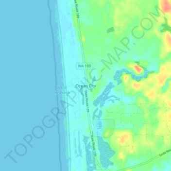
Name: Ocean City topographic map, elevation, terrain.

Location: Ocean City, Grays Harbor County, Washington, United States (47.04378 -124.17678 47.09776 -124.12416)

Average elevation: 8 m

Minimum elevation: -1 m

Maximum elevation: 38 m

Other topographic maps

Click on a map to view its topography, its elevation and its terrain.

Porter

United States > Washington > Grays Harbor County

Average elevation: 49 m

Artic

United States > Washington > Grays Harbor County

Average elevation: 75 m

Gear up for your next adventure:

Camping Groundsheet - Protect your tent from moisture and dirt
🥾Mountain Hiking Boots - High-traction boots for rocky terrain
🧢Beanie Hat - Keep your head warm in cold weather
🔭Compact Monocular - One-handed bird watching and trail spotting
🧣Merino Neck Gaiter - Protects against wind, sun, and cold at high altitudes

As an Amazon Associate, this site earns from qualifying purchases at no extra cost to you.