Geolocate

Mount Stuart topographic map

Click on the map to display elevation.

About this map

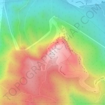
Name: Mount Stuart topographic map, elevation, terrain.

Location: Mount Stuart, Townsville, Queensland, Australia (-19.34338 146.78051 -19.34328 146.78061)

Average elevation: 300 m

Minimum elevation: 22 m

Maximum elevation: 582 m

Other topographic maps

Click on a map to view its topography, its elevation and its terrain.

Magnetic Island

Australia > Queensland > Townsville

Average elevation: 54 m

Castle Hill

Australia > Queensland > Townsville

Average elevation: 39 m

Pallarenda

Australia > Queensland > Townsville

Average elevation: 14 m

The Strand

Australia > Queensland > Townsville

Average elevation: 21 m

Victoria Park

Australia > Queensland > Townsville

Average elevation: 7 m

West End

Australia > Queensland > Townsville

Average elevation: 32 m

Magnetic Island

Australia > Queensland > Townsville

Average elevation: 54 m

Castle Hill

Australia > Queensland > Townsville

Average elevation: 39 m

Gear up for your next adventure:

🥾Hiking Shorts - Breathable shorts suitable for summer hikes
🥾Lightweight Hiking Boots - Boots for comfort and mobility on long hikes
🧥Waterproof Hiking Jacket - Protect yourself from rain and wind while hiking
🧥Fleece Jacket - Warm and lightweight jacket for layering
🧴Waterproofing Spray - Restore the DWR coating on jackets and tents

As an Amazon Associate, this site earns from qualifying purchases at no extra cost to you.