Geolocate

Victoria Park topographic map

Click on the map to display elevation.

About this map

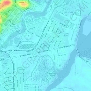
Name: Victoria Park topographic map, elevation, terrain.

Location: Victoria Park, South Townsville, Townsville, Townsville City, Queensland, Australia (-19.26937 146.82397 -19.26591 146.82713)

Average elevation: 7 m

Minimum elevation: 0 m

Maximum elevation: 62 m

Other topographic maps

Click on a map to view its topography, its elevation and its terrain.

Magnetic Island

Australia > Queensland > Townsville

Average elevation: 32 m

Hervey Range

Australia > Queensland > Townsville

Average elevation: 166 m

Mount Louisa

Australia > Queensland > Townsville

Average elevation: 28 m

Castle Hill

Australia > Queensland > Townsville

Average elevation: 40 m

Mount Stuart

Australia > Queensland > Townsville

Average elevation: 300 m

Castle Hill

Australia > Queensland > Townsville

Average elevation: 39 m

Pallarenda

Australia > Queensland > Townsville

Average elevation: 14 m

Bald Rock

Australia > Queensland > Townsville

Average elevation: 28 m

West End

Australia > Queensland > Townsville

Average elevation: 32 m

Castle Hill

Australia > Queensland > Townsville

Average elevation: 39 m

Gear up for your next adventure:

🛁Quick-Dry Microfiber Towel - Space-saving towel that dries rapidly on the move
🚑Survival Whistle - Signal for help across long distances in mountains
🥾Light Trekking Boots - Supportive boots for multi-day treks
🧼Travel Hand Sanitizer - Keep hands clean when water is scarce
🎒Hiking Backpack - Lightweight and ergonomic backpacks for day hikes or multi-day treks

As an Amazon Associate, this site earns from qualifying purchases at no extra cost to you.