
Luxembourg topographic map
Interactive map
Click on the map to display elevation.
About this map
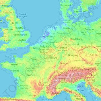
Name: Luxembourg topographic map, elevation, terrain.
Location: Luxembourg (42.81587 -0.87032 56.81587 13.12968)
Average elevation: 229 m
Minimum elevation: -6 m
Maximum elevation: 3,738 m
Other topographic maps
Click on a map to view its topography, its elevation and its terrain.
Luxembourg
Luxembourg > Canton Luxembourg
Luxembourg, Canton Luxembourg, Luxembourg
Average elevation: 312 m
Bertrange
Luxembourg > Canton Luxembourg
Bertrange, Canton Luxembourg, Luxembourg
Average elevation: 304 m
Esch-sur-Alzette
Esch-sur-Alzette, Canton Esch-sur-Alzette, Luxembourg
Average elevation: 332 m