
Make a donation
Gear up for your next adventure:
As an Amazon Associate, this site earns from qualifying purchases at no extra cost to you.
Rheinbrohl topographic map
Click on the map to display elevation.
Make a donation
Gear up for your next adventure:
As an Amazon Associate, this site earns from qualifying purchases at no extra cost to you.
Rheinbrohl
Zur Gemeinde Rheinbrohl gehören der Ortsteil Arienheller sowie die Wohnplätze Annahof, Berghof, Christinenhöhe, Dielsberg, Hartmannshof, Haus Bergfriede, Haus Forst, Jagdhaus Wilhelmsruh, Lampenthalerhof, Magdalenenhof und Zur alten Mühle.
Make a donation
Gear up for your next adventure:
As an Amazon Associate, this site earns from qualifying purchases at no extra cost to you.
About this map
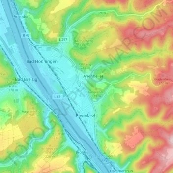
Name: Rheinbrohl topographic map, elevation, terrain.
Average elevation: 164 m
Minimum elevation: 52 m
Maximum elevation: 359 m
Make a donation
Gear up for your next adventure:
As an Amazon Associate, this site earns from qualifying purchases at no extra cost to you.
Other topographic maps
Click on a map to view its topography, its elevation and its terrain.
Altwied
Deutschland > Rheinland-Pfalz > Landkreis Neuwied > Neuwied
Im Zuge der weiteren Befestigung der Burg wurde der Burgflecken in das Befestigungssystem mit einbezogen. Die Mauer hatte eine Gesamtlänge von 500 m, die Mauerhöhe betrug 4 bis 5 m, im Osten erreichte die Mauer 8 m und war mit Wehrgang, Zinnen und Bogenfries versehen. Die Mauer war verstärkt durch vier…
Average elevation: 180 m
Drinhausen
Deutschland > Rheinland-Pfalz > Landkreis Neuwied
Das Dorf liegt im Niederwesterwald südwestlich des Hauptortes Asbach auf einer Anhöhe südlich des Asbachs und der Landesstraße 272, die Asbach mit der Bundesautobahn 3 (AS Bad Honnef/Linz) verbindet. Der Ort ist über die Kreisstraße 42 mit Bennau und Asbach verbunden.
Average elevation: 260 m
Make a donation
Gear up for your next adventure:
As an Amazon Associate, this site earns from qualifying purchases at no extra cost to you.
Rheinisches Schiefergebirge
Deutschland > Rheinland-Pfalz > Landkreis Neuwied > Rengsdorf
Average elevation: 258 m
Make a donation
Gear up for your next adventure:
As an Amazon Associate, this site earns from qualifying purchases at no extra cost to you.
Kapaunsmühle
Deutschland > Rheinland-Pfalz > Landkreis Neuwied > Altenhofen
Altenburg | Altenhofen | Asbach | Bennau | Bennauermühle | Büsch | Dasbach | Diefenau | Dinspel | Ditscheid | Drinhausen | Ehrenstein | Germscheid | Graben | Heckenhahn | Heide | Hinterplag | Hofen | Hussen | Kalscheid | Kaltehöhe | Kapaunsmühle | Köttingen | Krankel | Krumbach | Krumbachsmühle |…
Average elevation: 237 m
Straßen
Deutschland > Rheinland-Pfalz > Landkreis Neuwied > Oberplag
Altenburg | Altenhofen | Asbach | Bennau | Bennauermühle | Büsch | Dasbach | Diefenau | Dinspel | Ditscheid | Drinhausen | Ehrenstein | Germscheid | Graben | Heckenhahn | Heide | Hinterplag | Hofen | Hussen | Kalscheid | Kaltehöhe | Kapaunsmühle | Köttingen | Krankel | Krumbach | Krumbachsmühle |…
Average elevation: 248 m
Make a donation
Gear up for your next adventure:
As an Amazon Associate, this site earns from qualifying purchases at no extra cost to you.
Erpeler Ley
Deutschland > Rheinland-Pfalz > Landkreis Neuwied > Erpel
Über die Erpeler Ley führt der Rotbäckchen-Wanderweg sowie der Rheinsteig, das Plateau ist über die asphaltierte Zufahrtsstraße (von der B42 Ausfahrt Erpel, ab da ausgeschildert) erreichbar. Aus Richtung Bruchhausen und Unkel führen verschiedene ausgebaute Wanderwege zur Erpeler Ley. Auf dem Plateau sind…
Average elevation: 102 m
Krankel
Deutschland > Rheinland-Pfalz > Landkreis Neuwied > Asbach > Krankel
Das Dorf liegt im Niederwesterwald südöstlich des Hauptortes Asbach auf einer Anhöhe oberhalb und nördlich des Dinspeler Bachs. Krankel liegt nahe der Landesstraße 272, die Asbach mit Flammersfeld verbindet. Von Krankel aus führt die Kreisstraße 68 zu dem Asbacher Ortsteil Dinspel und die Kreisstraße…
Average elevation: 254 m
Make a donation
Gear up for your next adventure:
As an Amazon Associate, this site earns from qualifying purchases at no extra cost to you.
Make a donation
Gear up for your next adventure:
As an Amazon Associate, this site earns from qualifying purchases at no extra cost to you.
Make a donation
Gear up for your next adventure:
As an Amazon Associate, this site earns from qualifying purchases at no extra cost to you.
Notscheid
Deutschland > Rheinland-Pfalz > Landkreis Neuwied
Landesherrlich gehörte Notscheid bis zum Beginn des 19. Jahrhunderts zum Kurfürstentum Köln. Der westliche und ursprünglich größere Teil des Dorfs gehörte zum Kirchspiel und zum kurkölnischen Amt Linz. Zusammen mit den Orten Hargarten, Hilkerscheid, Noll und Ginsterhahn waren die Ortschaften ein…
Average elevation: 311 m
Make a donation
Gear up for your next adventure:
As an Amazon Associate, this site earns from qualifying purchases at no extra cost to you.
Köhlershohn
Deutschland > Rheinland-Pfalz > Landkreis Neuwied
Köhlershohn weist das Siedlungsbild eines Straßendorfs auf, das sich entlang der Kreisstraße 27 (Schweifeld–Windhagen) zieht. Die Ortschaft erstreckt sich vom Tal des Rederscheider Baches im Südwesten ansteigend bis zum Rand der Bundesautobahn 3 im Nordosten und umfasst dabei Höhenlagen zwischen 250 und…
Average elevation: 287 m
Make a donation
Gear up for your next adventure:
As an Amazon Associate, this site earns from qualifying purchases at no extra cost to you.
Oberelles
Deutschland > Rheinland-Pfalz > Landkreis Neuwied > Buchholz (Westerwald)
Average elevation: 258 m
Make a donation
Gear up for your next adventure:
As an Amazon Associate, this site earns from qualifying purchases at no extra cost to you.
Germscheid
Deutschland > Rheinland-Pfalz > Landkreis Neuwied
Das Dorf liegt im Niederwesterwald westlich des Hauptortes Asbach auf einer Anhöhe zwischen dem oberen Pfaffenbachtal und dem Stockhausener Bach. Im Westen grenzt Germscheid an die zur Ortsgemeinde Windhagen gehörende Ortschaft Stockhausen. Im Nordwesten grenzt Germscheid an Nordrhein-Westfalen und an die…
Average elevation: 265 m
Make a donation
Gear up for your next adventure:
As an Amazon Associate, this site earns from qualifying purchases at no extra cost to you.
Günterscheid
Deutschland > Rheinland-Pfalz > Landkreis Neuwied
Günterscheid liegt zwei Kilometer südöstlich des Ortszentrums von Windhagen auf einem von Westen nach Osten zu einem linken Zufluss des Elsaffer Bachs abfallenden Gelände. Der Zufluss durchfließt das sogenannte Appental und wird nördlich von Günterscheid in Teichen gestaut, ein bachbegleitender…
Average elevation: 250 m
Make a donation
Gear up for your next adventure:
As an Amazon Associate, this site earns from qualifying purchases at no extra cost to you.
Kretzhaus
Deutschland > Rheinland-Pfalz > Landkreis Neuwied > Vettelschoß > Kretzhaus
Kretzhaus liegt zwischen 350 und 365 m ü. NHN auf dem Rheinwesterwälder Vulkanrücken (Niederwesterwald), nordöstlich des Meerbergs (429 m ü. NHN). Es erstreckt sich als Straßendorf entlang der Landesstraße 253, die von Rottbitze über Kretzhaus hinab nach Linz am Rhein führt; die hier am Ortsausgang…
Average elevation: 317 m
Make a donation
Gear up for your next adventure:
As an Amazon Associate, this site earns from qualifying purchases at no extra cost to you.
Rederscheid
Deutschland > Rheinland-Pfalz > Landkreis Neuwied
Rederscheid liegt auf 300 m ü. NHN, 7 km östlich der Stadt Bad Honnef und etwa 2 km westlich des Ortszentrums von Windhagen. Es erstreckt sich als Straßendorf entlang der Kreisstraße 26 (Landesgrenze Richtung Rottbitze – Hallerbach – Unterelsaff) auf einem flachen, im Durchschnitt 300 m hohen…
Average elevation: 301 m
Make a donation
Gear up for your next adventure:
As an Amazon Associate, this site earns from qualifying purchases at no extra cost to you.
Reuschenbach
Deutschland > Rheinland-Pfalz > Landkreis Neuwied > Hausen (Wied)
Average elevation: 234 m
Strödt
Deutschland > Rheinland-Pfalz > Landkreis Neuwied > Sankt Katharinen > Strödt
Average elevation: 283 m
Hüngsberg
Deutschland > Rheinland-Pfalz > Landkreis Neuwied > Windhagen > Hüngsberg
Der Weiler Hüngsberg liegt zwei Kilometer östlich des Ortszentrums von Windhagen auf einem nach Osten zum Tal des Pfaffenbachs abfallenden Bergrücken. Die Ortschaft umfasst Höhenlagen zwischen 245 und 260 m ü. NHN. Zu den nächstgelegenen Orten gehören Johannisberg im Nordwesten sowie der Wohnplatz…
Average elevation: 251 m
Make a donation
Gear up for your next adventure:
As an Amazon Associate, this site earns from qualifying purchases at no extra cost to you.
Noll
Deutschland > Rheinland-Pfalz > Landkreis Neuwied > Hargarten
Noll unterstand als Teil der Linzer Höhe bis zum Beginn des 19. Jahrhunderts der Verwaltung des kurkölnischen Amtes Linz. Seit 1809 gehörte die Ortschaft zur neugebildeten Gemeinde Hargarten (lediglich zwei Häuser am Ortsrand zur Gemeinde Notscheid), ab 1816 im Verwaltungsbezirk der Bürgermeisterei Linz.…
Average elevation: 310 m
Make a donation
Gear up for your next adventure:
As an Amazon Associate, this site earns from qualifying purchases at no extra cost to you.