Geolocate

Fairfax topographic map

Click on the map to display elevation.

About this map

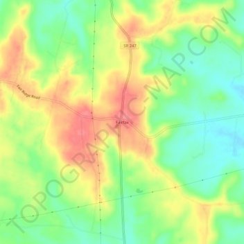
Name: Fairfax topographic map, elevation, terrain.

Location: Fairfax, Highland County, Ohio, United States (39.02785 -83.60742 39.06785 -83.56742)

Average elevation: 307 m

Minimum elevation: 271 m

Maximum elevation: 347 m

Other topographic maps

Click on a map to view its topography, its elevation and its terrain.

Rocky Fork Lake

United States > Ohio > Highland County

Average elevation: 291 m

Lynchburg

United States > Ohio > Highland County

Average elevation: 310 m

Hillsboro

United States > Ohio > Highland County

Average elevation: 313 m

Highland

United States > Ohio > Highland County

Average elevation: 326 m

Paint Creek Lake

United States > Ohio > Highland County

Average elevation: 277 m

Mowrystown

United States > Ohio > Highland County

Average elevation: 299 m

Gear up for your next adventure:

🧶550 Survival Paracord - Versatile utility cord for emergency repairs and rigging
🥾Mountain Hiking Shoes - Shoes with superior grip for mountainous terrain
🧊Portable Cooler - Keep food and drinks cold during outdoor adventures
💡Solar Camping Lamp - Eco-friendly lighting for campsites
🚲Handlebar Phone Mount - View topographic-map.com live while cycling

As an Amazon Associate, this site earns from qualifying purchases at no extra cost to you.