
Make a donation
Gear up for your next adventure:
As an Amazon Associate, this site earns from qualifying purchases at no extra cost to you.
Hulu Kelang topographic map
Click on the map to display elevation.
Make a donation
Gear up for your next adventure:
As an Amazon Associate, this site earns from qualifying purchases at no extra cost to you.
Hulu Kelang
It has an area of 16.94 square kilometres, and is located northeast of Kuala Lumpur. The surface is relatively high; 500 metres above sea level, and the topography here is highland, lowland, or undulating land. As a result, it is a rain catchment area for the Klang River. Among the high locations are Bukit Antarabangsa, Bukit Kemensah, and Bukit Belacan. The hill is composed of limestone, which is brittle and dissolves during heavy rains. As a result, several landslides have occurred in this area, forcing people mainly living in flats, as well as some houses on the hillside, to evacuate. A notable incident is the collapse of Highland Towers in 1993. Moreover, the flow of the Klang River was straightened in several places, which caused water to flow faster, leading Kuala Lumpur to experience flash floods on June 10, 2007.
Make a donation
Gear up for your next adventure:
As an Amazon Associate, this site earns from qualifying purchases at no extra cost to you.
About this map
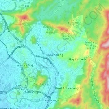
Name: Hulu Kelang topographic map, elevation, terrain.
Average elevation: 147 m
Minimum elevation: 40 m
Maximum elevation: 469 m
Make a donation
Gear up for your next adventure:
As an Amazon Associate, this site earns from qualifying purchases at no extra cost to you.
Other topographic maps
Click on a map to view its topography, its elevation and its terrain.
Make a donation
Gear up for your next adventure:
As an Amazon Associate, this site earns from qualifying purchases at no extra cost to you.
Ampang River
Malaysia > Selangor > Ampang Jaya Municipal Council > Kampung Muhibbah
Average elevation: 71 m
Make a donation
Gear up for your next adventure:
As an Amazon Associate, this site earns from qualifying purchases at no extra cost to you.
Kawasan Rekreasi AU2 Keramat
Malaysia > Selangor > Ampang Jaya Municipal Council
Average elevation: 74 m