
Al-Qutayfah District topographic map
Interactive map
Click on the map to display elevation.
About this map
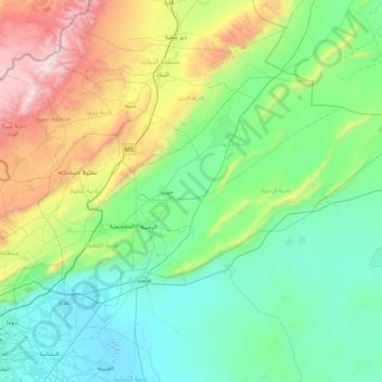
Name: Al-Qutayfah District topographic map, elevation, terrain.
Location: Al-Qutayfah District, Rif Dimashq Governorate, Syria (33.59879 36.45839 34.01796 37.30016)
Average elevation: 1,053 m
Minimum elevation: 595 m
Maximum elevation: 2,623 m
Other topographic maps
Click on a map to view its topography, its elevation and its terrain.
Dumayr
Syria > Rif Dimashq Governorate
Dumayr, Al-Dumayr Sudsitrict, Douma District, Rif Dimashq Governorate, Syria
Average elevation: 694 m
Markaz Rif Dimashq District
Syria > Rif Dimashq Governorate
Markaz Rif Dimashq District, Rif Dimashq Governorate, 988, Syria
Average elevation: 726 m
Al Kiswah
Syria > Rif Dimashq Governorate
Al Kiswah, Al-Kiswah Sudsitrict, Markaz Rif Dimashq District, Rif Dimashq Governorate, Syria
Average elevation: 753 m