
Saint Pierre and Miquelon topographic map
Interactive map
Click on the map to display elevation.
About this map
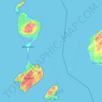
Name: Saint Pierre and Miquelon topographic map, elevation, terrain.
Location: Saint Pierre and Miquelon, France (46.74946 -56.51613 47.14426 -56.11896)
Average elevation: 11 m
Minimum elevation: -1 m
Maximum elevation: 230 m
Other topographic maps
Click on a map to view its topography, its elevation and its terrain.
Le Grand Meslier
France > Normandy > Manche > Carentan-les-Marais > Houesville
Average elevation: 15 m
Pointe du Villonet
France > Auvergne-Rhône-Alpes > Savoy > Saint-Colomban-des-Villards
Average elevation: 2,256 m
Éboulement de Vérel
France > Auvergne-Rhône-Alpes > Savoy > Verel-Pragondran > Vérel > Les Chavannes
Average elevation: 753 m
Colombis
France > Provence-Alpes-Côte d'Azur > Vaucluse > Châteauneuf-du-Pape > La Croze
Average elevation: 58 m
Langély
France > Nouvelle-Aquitaine > Corrèze > Arnac-Pompadour > Le Queyraud Haut
Average elevation: 346 m
La Basse Gambrie
France > Brittany > Ille-et-Vilaine > La Chapelle-Fleurigné > Fleurigné
Average elevation: 180 m
La Brutz
France > Pays de la Loire > Loire-Atlantique > Rougé > La Grée Pothin
Average elevation: 65 m
Les Huguets
France > Auvergne-Rhône-Alpes > Ain > Saint-Didier-sur-Chalaronne
Average elevation: 184 m
La Petite Cour Batonnerie
France > Bourgogne-Franche-Comté > Yonne > Toucy > La Mine d'Or
Average elevation: 257 m
La Quenouillère
France > Pays de la Loire > Maine-et-Loire > Brain-sur-Longuenée
Average elevation: 68 m
Avignon
France > Provence-Alpes-Côte d'Azur > Vaucluse > Avignon
Enclosed by the city walls, the Rocher des Doms is a limestone elevation of Urgonian type, 35 metres high (and therefore safe from flooding of the Rhone which it overlooks) and is the original core of the city. Several limestone massifs are present around the commune (the Massif des Angles,…
Average elevation: 58 m
Raphèle-lès-Arles
France > Provence-Alpes-Côte d'Azur > Bouches-du-Rhône > Arles
Average elevation: 13 m
Le Bois Chapeleau
France > Nouvelle-Aquitaine > Deux-Sèvres > Beugnon-Thireuil
Average elevation: 120 m
La mare aux éléphants
France > French Southern and Antarctic Lands > Martin-de-Viviès
Average elevation: 40 m
Le Cotel
France > Auvergne-Rhône-Alpes > Isère > Autrans-Méaudre en Vercors > Méaudre
Average elevation: 1,108 m
Canal de Fumemorte
France > Provence-Alpes-Côte d'Azur > Bouches-du-Rhône > Arles
Average elevation: 0 m
Seche Bec
France > Nouvelle-Aquitaine > Deux-Sèvres > Niort > Le Petit Chauveux
Average elevation: 47 m
Prairie
France > Hauts-de-France > Cuignières
Certain extraordinary features were produced when the retreat of the ice sheet had progressed so far as to open an eastward outlet for the marginal lakes. This outlet occurred along the depression between the northward slope of the Appalachian plateau in west-central New York and the southward slope of the…
Average elevation: 136 m
Mont Maudit / Monte Maudit
France > Auvergne-Rhône-Alpes > Upper Savoy > Chamonix-Mont-Blanc
Average elevation: 3,871 m
Archiane
France > Auvergne-Rhône-Alpes > Drôme > Châtillon-en-Diois > Archiane
Average elevation: 1,134 m