Geolocate

Penetang topographic map

Click on the map to display elevation.

About this map

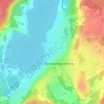
Name: Penetang topographic map, elevation, terrain.

Location: Penetang, Penetanguishene, Simcoe County, Central Ontario, Ontario, L9M 1C1, Canada (44.76178 -79.94657 44.78178 -79.92657)

Average elevation: 202 m

Minimum elevation: 175 m

Maximum elevation: 251 m

Simcoe County trails, hiking, mountain biking, running and outdoor activities

Other topographic maps

Click on a map to view its topography, its elevation and its terrain.

Gear up for your next adventure:

🛌Down Sleeping Bag - Superior warmth-to-weight ratio for cold nights
🧰Multitool Knife - Compact and versatile tool for outdoor use
👟Sport Hiking Sandals - Breathable footwear for water crossings and camp rest
🧊Portable Cooler - Keep food and drinks cold during outdoor adventures
🥾Durable Hiking Shoes - Long-lasting shoes for frequent hiking

As an Amazon Associate, this site earns from qualifying purchases at no extra cost to you.