
Thank you for supporting this site ❤️
Make a donation
Make a donation
Gear up for your next adventure:
As an Amazon Associate, this site earns from qualifying purchases at no extra cost to you.
Castro Laboreiro topographic map
Click on the map to display elevation.
Thank you for supporting this site ❤️
Make a donation
Make a donation
Gear up for your next adventure:
As an Amazon Associate, this site earns from qualifying purchases at no extra cost to you.
About this map
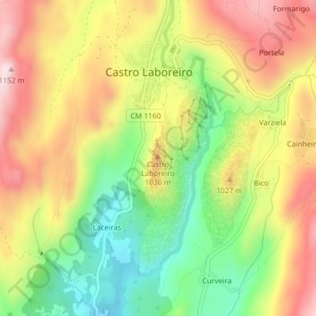
Name: Castro Laboreiro topographic map, elevation, terrain.
Average elevation: 943 m
Minimum elevation: 757 m
Maximum elevation: 1,131 m
Thank you for supporting this site ❤️
Make a donation
Make a donation
Gear up for your next adventure:
As an Amazon Associate, this site earns from qualifying purchases at no extra cost to you.
Other topographic maps
Click on a map to view its topography, its elevation and its terrain.
Castro Laboreiro
Portugal > Nord > Castro Laboreiro e Lamas de Mouro
Curral do Gonçalo, dans la paroisse de Castro Laboreiro, est situé à une altitude de 1 166 mètres, ce qui en fait le deuxième lieu habité le plus élevé du Portugal.
Average elevation: 994 m