
Make a donation
Gear up for your next adventure:
As an Amazon Associate, this site earns from qualifying purchases at no extra cost to you.
Castro Laboreiro topographic map
Click on the map to display elevation.
Make a donation
Gear up for your next adventure:
As an Amazon Associate, this site earns from qualifying purchases at no extra cost to you.
Castro Laboreiro
Curral do Gonçalo, dans la paroisse de Castro Laboreiro, est situé à une altitude de 1 166 mètres, ce qui en fait le deuxième lieu habité le plus élevé du Portugal.
Make a donation
Gear up for your next adventure:
As an Amazon Associate, this site earns from qualifying purchases at no extra cost to you.
About this map
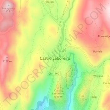
Name: Castro Laboreiro topographic map, elevation, terrain.
Average elevation: 994 m
Minimum elevation: 779 m
Maximum elevation: 1,167 m
Make a donation
Gear up for your next adventure:
As an Amazon Associate, this site earns from qualifying purchases at no extra cost to you.
Other topographic maps
Click on a map to view its topography, its elevation and its terrain.