Geolocate

Century topographic map

Click on the map to display elevation.

About this map

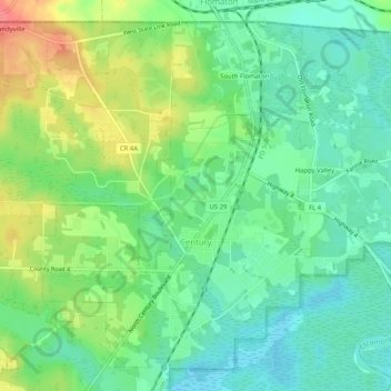
Name: Century topographic map, elevation, terrain.

Location: Century, Escambia County, Florida, United States (30.95891 -87.28517 30.99791 -87.23409)

Average elevation: 31 m

Minimum elevation: 5 m

Maximum elevation: 78 m

Other topographic maps

Click on a map to view its topography, its elevation and its terrain.

Brownsville

United States > Florida > Escambia County

Average elevation: 21 m

Bohemia

United States > Florida > Escambia County > Pensacola

Average elevation: 15 m

Molino

United States > Florida > Escambia County

Average elevation: 26 m

Ensley

United States > Florida > Escambia County > Ensley

Average elevation: 35 m

Gull Point

United States > Florida > Escambia County > Pensacola

Average elevation: 10 m

Gear up for your next adventure:

👟Leg Gaiters - Keep debris, mud, and snow out of your boots
🚲MTB Frame Bag - Carry tools and maps directly on your bicycle frame
🧰Emergency Multi-Tool - Compact multi-tool for outdoor survival
🧥Waterproof Hiking Jacket - Protect yourself from rain and wind while hiking
🧦Hiking Socks - Moisture-wicking and comfortable socks for long hikes

As an Amazon Associate, this site earns from qualifying purchases at no extra cost to you.