
Make a donation
Gear up for your next adventure:
As an Amazon Associate, this site earns from qualifying purchases at no extra cost to you.
East Huntingdon Township topographic map
Click on the map to display elevation.
Make a donation
Gear up for your next adventure:
As an Amazon Associate, this site earns from qualifying purchases at no extra cost to you.
About this map
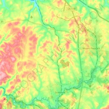
Name: East Huntingdon Township topographic map, elevation, terrain.
Average elevation: 357 m
Minimum elevation: 280 m
Maximum elevation: 456 m
Make a donation
Gear up for your next adventure:
As an Amazon Associate, this site earns from qualifying purchases at no extra cost to you.
Other topographic maps
Click on a map to view its topography, its elevation and its terrain.
Circleville
United States > Pennsylvania > Westmoreland County > North Huntingdon Township
Average elevation: 333 m
Donegal Lake
United States > Pennsylvania > Westmoreland County > Donegal Township
Average elevation: 493 m
Acme
United States > Pennsylvania > Westmoreland County > Mount Pleasant Township
Average elevation: 585 m
Stahlstown
United States > Pennsylvania > Westmoreland County > Cook Township
Average elevation: 514 m
Make a donation
Gear up for your next adventure:
As an Amazon Associate, this site earns from qualifying purchases at no extra cost to you.
Twin Lakes Park
United States > Pennsylvania > Westmoreland County > Hempfield Township > Luxor > Georges Station
Average elevation: 367 m
Bessemer
United States > Pennsylvania > Westmoreland County > East Huntingdon Township
Average elevation: 342 m
Make a donation
Gear up for your next adventure:
As an Amazon Associate, this site earns from qualifying purchases at no extra cost to you.
Southwest
United States > Pennsylvania > Westmoreland County > Mount Pleasant Township
Average elevation: 336 m
United
United States > Pennsylvania > Westmoreland County > Mount Pleasant Township
Average elevation: 326 m
Perryville
United States > Pennsylvania > Westmoreland County > Bell Township
Average elevation: 365 m
Make a donation
Gear up for your next adventure:
As an Amazon Associate, this site earns from qualifying purchases at no extra cost to you.
Chestnut Ridge
United States > Pennsylvania > Westmoreland County > Fairfield Township
Average elevation: 466 m
Morewood
United States > Pennsylvania > Westmoreland County > East Huntingdon Township
Average elevation: 357 m
Tarrs
United States > Pennsylvania > Westmoreland County > East Huntingdon Township
Average elevation: 356 m
Make a donation
Gear up for your next adventure:
As an Amazon Associate, this site earns from qualifying purchases at no extra cost to you.
Buckeye
United States > Pennsylvania > Westmoreland County > East Huntingdon Township
Average elevation: 338 m
Alverton
United States > Pennsylvania > Westmoreland County > East Huntingdon Township
Average elevation: 361 m
Turkeytown
United States > Pennsylvania > Westmoreland County > South Huntingdon Township
Average elevation: 317 m
Painter Rock Hill
United States > Pennsylvania > Westmoreland County > Donegal Township
Average elevation: 781 m
Make a donation
Gear up for your next adventure:
As an Amazon Associate, this site earns from qualifying purchases at no extra cost to you.
Collinsburg
United States > Pennsylvania > Westmoreland County > Rostraver Township
Average elevation: 282 m
Camp Jo-Ann
United States > Pennsylvania > Westmoreland County > Murrysville > Camp Jo-Ann
Average elevation: 343 m
Maplewood Terrace
United States > Pennsylvania > Westmoreland County > Hempfield Township > Maplewood Terrace
Average elevation: 346 m
Bessemer
United States > Pennsylvania > Westmoreland County > East Huntingdon Township > Bessemer
Average elevation: 342 m
Make a donation
Gear up for your next adventure:
As an Amazon Associate, this site earns from qualifying purchases at no extra cost to you.
Keystone State Park
United States > Pennsylvania > Westmoreland County > Derry Township
Average elevation: 352 m
Yukon
United States > Pennsylvania > Westmoreland County > South Huntingdon Township
Average elevation: 315 m