Geolocate

Circleville topographic map

Click on the map to display elevation.

About this map

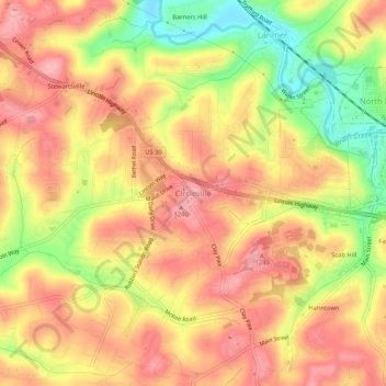
Name: Circleville topographic map, elevation, terrain.

Location: Circleville, North Huntingdon Township, Westmoreland County, Pennsylvania, 15647, United States (40.30892 -79.75721 40.34892 -79.71721)

Average elevation: 333 m

Minimum elevation: 252 m

Maximum elevation: 384 m

Other topographic maps

Click on a map to view its topography, its elevation and its terrain.

Gear up for your next adventure:

📷Outdoor Action Camera - Capture high-elevation views and rugged adventures
🧢Sun Hat - Wide-brim hat for sun protection
🥾Mountain Hiking Boots - High-traction boots for rocky terrain
🦶Hiking Shoe Insoles - Added support for high arches and long days on feet
🥾Trail Running Shoes - Lightweight and durable shoes for trail running

As an Amazon Associate, this site earns from qualifying purchases at no extra cost to you.