
Chez les Bonnets topographic map
Click on the map to display elevation.
About this map
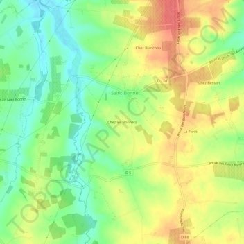
Name: Chez les Bonnets topographic map, elevation, terrain.
Average elevation: 77 m
Minimum elevation: 46 m
Maximum elevation: 110 m
Other topographic maps
Click on a map to view its topography, its elevation and its terrain.
Le Beau
France > Nouvelle-Aquitaine > Charente > Saint-Bonnet
D'une longueur de 22,4 kilomètres, le Beau prend sa source sur la commune de Chillac à l'altitude 140 mètres, à l'ouest du château de Chillac. Un peu plus au nord du château, près du Grand Chiron, sa source principale est la Grand Font. Le Beau s'appelle ruisseau de la Grande Fontaine près de sa…
Average elevation: 92 m