Geolocate

Rahbeh topographic map

Click on the map to display elevation.

About this map
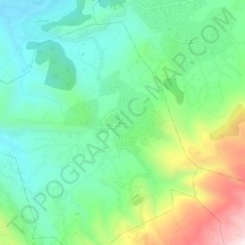
Name: Rahbeh topographic map, elevation, terrain.

Location: Rahbeh, Akkar District, Akkar Governorate, Lebanon (34.48507 36.12671 34.52507 36.16671)

Average elevation: 603 m

Minimum elevation: 345 m

Maximum elevation: 1,189 m

Other topographic maps

Click on a map to view its topography, its elevation and its terrain.

Akkar District

Lebanon > Akkar Governorate

Average elevation: 636 m

Srar

Lebanon > Akkar Governorate

Average elevation: 139 m

Sheikhlar

Lebanon > Akkar Governorate

Average elevation: 385 m

Ilat

Lebanon > Akkar Governorate

Average elevation: 397 m

Halba

Lebanon > Akkar Governorate

Average elevation: 102 m

Akkar District

Lebanon > Akkar Governorate

Average elevation: 636 m

Bebnine

Lebanon > Akkar Governorate

Average elevation: 68 m

Mounjez

Lebanon > Akkar Governorate

Average elevation: 353 m

Qarha Aakkar

Lebanon > Akkar Governorate

Average elevation: 519 m

Gear up for your next adventure:

☕Camping Coffee Maker - Brew fresh coffee anywhere on the topographic map
🪑Insulated Seat Pad - Protect your seat from cold rocks and wet logs
🥤Collapsible Travel Cup - Saves space and weight in your mess kit
🧴Outdoor Sunscreen - High SPF protection for high-altitude UV exposure
🧥Waterproof Jacket - Lightweight rain jackets for hiking and outdoor activities

As an Amazon Associate, this site earns from qualifying purchases at no extra cost to you.