
Muskogee County topographic map
Click on the map to display elevation.
About this map
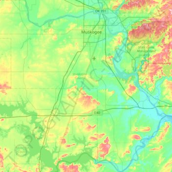
Name: Muskogee County topographic map, elevation, terrain.
Location: Muskogee County, Oklahoma, United States (35.26210 -95.76627 35.85766 -95.05057)
Average elevation: 190 m
Minimum elevation: 141 m
Maximum elevation: 328 m
Other topographic maps
Click on a map to view its topography, its elevation and its terrain.
Southwest Oklahoma City Sludge Lagoon Dam
United States > Oklahoma > Cleveland County > Oklahoma City
Average elevation: 348 m
Lake Thunderbird Dam
United States > Oklahoma > Cleveland County > Norman > Little Axe
Average elevation: 318 m