Geolocate

Long Ridge topographic map

Click on the map to display elevation.

About this map

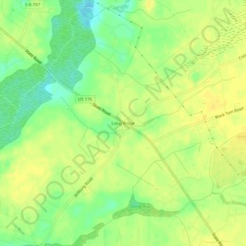
Name: Long Ridge topographic map, elevation, terrain.

Location: Long Ridge, Berkeley County, South Carolina, United States (33.12239 -80.18092 33.16239 -80.14092)

Average elevation: 19 m

Minimum elevation: 4 m

Maximum elevation: 26 m

Other topographic maps

Click on a map to view its topography, its elevation and its terrain.

Ladson

United States > South Carolina > Berkeley County

Average elevation: 14 m

Gear up for your next adventure:

🏕️Camping Hammock - Integrated protection for sleeping between trees
🏃Hydration Running Vest - Carry water and maps close to your body for speed
🛌Insulated Sleeping Pad - Critical thermal barrier between you and the cold ground
🛏️Sleeping Bag - Warm and compact sleeping bags for outdoor camping
Bushcraft Tarp - Versatile emergency shelter or gear protection

As an Amazon Associate, this site earns from qualifying purchases at no extra cost to you.