
Ovaro topographic map
Click on the map to display elevation.
About this map
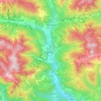
Name: Ovaro topographic map, elevation, terrain.
Location: Ovaro, Udine, Friuli – Venezia Giulia, 33025, Italy (46.44629 12.76496 46.52375 12.93710)
Average elevation: 1,066 m
Minimum elevation: 387 m
Maximum elevation: 2,037 m
Other topographic maps
Click on a map to view its topography, its elevation and its terrain.
Mangart Saddle
Italy > Friuli – Venezia Giulia > Udine > Tarvisio
Mangart Saddle or the Mangart Pass (Slovene: Mangartsko sedlo or Mangrtsko sedlo) is a mountain saddle in the Julian Alps in northwestern Slovenia. It has an elevation of 2,072 metres (6,798 ft). It is the most common starting point for the ascent of Mt. Mangart (2,679 m or 8,789 ft). The Mangart Road…
Average elevation: 1,780 m