
Make a donation
Gear up for your next adventure:
As an Amazon Associate, this site earns from qualifying purchases at no extra cost to you.
Mangart Saddle topographic map
Click on the map to display elevation.
Make a donation
Gear up for your next adventure:
As an Amazon Associate, this site earns from qualifying purchases at no extra cost to you.
Mangart Saddle
Mangart Saddle or the Mangart Pass (Slovene: Mangartsko sedlo or Mangrtsko sedlo) is a mountain saddle in the Julian Alps in northwestern Slovenia. It has an elevation of 2,072 metres (6,798 ft). It is the most common starting point for the ascent of Mt. Mangart (2,679 m or 8,789 ft). The Mangart Road (Mangartska cesta) that leads over Mangart Saddle, with its elevation of 2,055 m (6,742 ft), has a number of turns and is the highest-lying road in Slovenia. It was built in 1938. The Mangart Pass offers a picturesque view towards the Log Koritnica Valley in Slovenia to the south and the Lakes of Fusine in Italy to the north. The Mangart Saddle Lodge (koča na Mangrtskem sedlu) lies under the saddle. The saddle was the scenery of the film Let's Go Our Own Way. Mangart Saddle is also known as the finding place of manganese nodules from the Early Jurassic period.
Make a donation
Gear up for your next adventure:
As an Amazon Associate, this site earns from qualifying purchases at no extra cost to you.
About this map
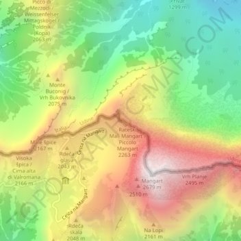
Name: Mangart Saddle topographic map, elevation, terrain.
Average elevation: 1,780 m
Minimum elevation: 1,022 m
Maximum elevation: 2,663 m
Make a donation
Gear up for your next adventure:
As an Amazon Associate, this site earns from qualifying purchases at no extra cost to you.