
Make a donation
Gear up for your next adventure:
As an Amazon Associate, this site earns from qualifying purchases at no extra cost to you.
Lech topographic map
Click on the map to display elevation.
Make a donation
Gear up for your next adventure:
As an Amazon Associate, this site earns from qualifying purchases at no extra cost to you.
Lech
The altitude of 1444 m for the village refers to the location of the old church on a hill. 14.1% of the municipal area is forested, 58% of the area is Alpine. Geographically and historically, Lech belongs to the Hochtannberg region, formerly Tannberg, but in terms of tourism the municipality is part of the Arlberg region. Lech belongs to the district of Bludenz and also to the judicial district of Bludenz, but unlike its southern neighboring communities of Klösterle and Dalaas, which also belong to the district of Bludenz, it is not located in the Klostertal, but in the Arlberg massif to the northeast of it.
Make a donation
Gear up for your next adventure:
As an Amazon Associate, this site earns from qualifying purchases at no extra cost to you.
About this map
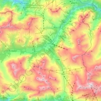
Name: Lech topographic map, elevation, terrain.
Location: Lech, Bezirk Bludenz, Vorarlberg, Austria (47.14803 10.03213 47.25166 10.21375)
Average elevation: 1,947 m
Minimum elevation: 1,164 m
Maximum elevation: 2,782 m
Make a donation
Gear up for your next adventure:
As an Amazon Associate, this site earns from qualifying purchases at no extra cost to you.
Other topographic maps
Click on a map to view its topography, its elevation and its terrain.
Montafon
Austria > Vorarlberg > Bezirk Bludenz > Gemeinde Sankt Gallenkirch
Tourism plays a vital role and the Montafon is well-known for its skiing, hiking, and mountain biking. The Silvretta high alpine road (German: Hochalpenstraße) gives access to remote ski areas that are located altitudes of 650 to 1,430 meters. The construction of the Montafon Railway in 1905 also helped…
Average elevation: 1,566 m