Geolocate

Tulunan topographic map

Click on the map to display elevation.

About this map

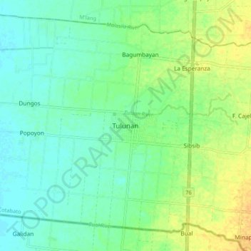
Name: Tulunan topographic map, elevation, terrain.

Location: Tulunan, North Cotabato, Soccsksargen, Philippines (6.79002 124.83365 6.87002 124.91365)

Average elevation: 21 m

Minimum elevation: 10 m

Maximum elevation: 38 m

Other topographic maps

Click on a map to view its topography, its elevation and its terrain.

Lake Jordan

Philippines > North Cotabato > Makilala

Average elevation: 2,383 m

President Roxas

Philippines > North Cotabato

Average elevation: 364 m

Gear up for your next adventure:

🍽️Titanium Camping Spork - Ultralight and indestructible eating utensil
💡Compact LED Flashlight - Powerful and portable flashlight for outdoor use
Lightweight Backpacking Tent - Compact tent for efficient hiking trips
🥾Waterproof Trail Shoes - Shoes designed to handle wet terrain
🥾Mountain Hiking Boots - High-traction boots for rocky terrain

As an Amazon Associate, this site earns from qualifying purchases at no extra cost to you.