
Make a donation
Gear up for your next adventure:
As an Amazon Associate, this site earns from qualifying purchases at no extra cost to you.
Maycroft topographic map
Click on the map to display elevation.
Make a donation
Gear up for your next adventure:
As an Amazon Associate, this site earns from qualifying purchases at no extra cost to you.
About this map
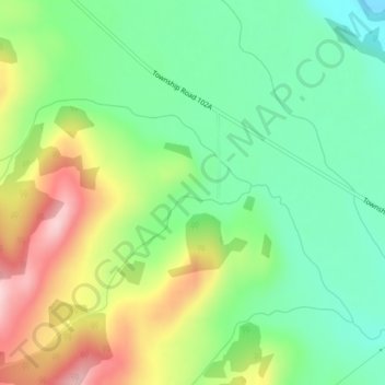
Name: Maycroft topographic map, elevation, terrain.
Average elevation: 1,373 m
Minimum elevation: 1,284 m
Maximum elevation: 1,515 m
Make a donation
Gear up for your next adventure:
As an Amazon Associate, this site earns from qualifying purchases at no extra cost to you.
Other topographic maps
Click on a map to view its topography, its elevation and its terrain.
Carbondale River
Canada > Alberta > Municipal District of Pincher Creek No. 9
Average elevation: 1,565 m
Beaver Mines Lake
Canada > Alberta > Municipal District of Pincher Creek No. 9
Average elevation: 1,538 m
Castle Provincial Park
Canada > Alberta > Municipal District of Pincher Creek No. 9
The Castle Provincial Park has a unique climate which has allowed the growth of many unique plant and animal species. This climate is formed because of the transition of subalpine forest to tundra, and is characterized by short summers interchanged with long, snowy winters. Precipitation varies throughout the…
Average elevation: 1,587 m
Make a donation
Gear up for your next adventure:
As an Amazon Associate, this site earns from qualifying purchases at no extra cost to you.