Geolocate

Owen topographic map

Click on the map to display elevation.

About this map

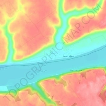
Name: Owen topographic map, elevation, terrain.

Location: Owen, Clark County, Indiana, United States (38.43812 -85.56190 38.47812 -85.52190)

Average elevation: 182 m

Minimum elevation: 128 m

Maximum elevation: 229 m

Other topographic maps

Click on a map to view its topography, its elevation and its terrain.

Oak Park

United States > Indiana > Clark County

Average elevation: 140 m

New Washington

United States > Indiana > Clark County

Average elevation: 214 m

Memphis

United States > Indiana > Clark County

Average elevation: 153 m

Utica

United States > Indiana > Clark County

Average elevation: 142 m

Gear up for your next adventure:

🔪Outdoor Multitool - Versatile tool for repairs and food prep in the wild
🐕Hiking Dog Pack - Let your canine companion carry their own water and food
🥾Trekking Boots - Durable boots for long-distance trekking
🧥Softshell Hiking Jacket - The perfect balance of wind protection and breathability
🚲Bike Repair Kit - Essential tools for on-trail mechanical issues

As an Amazon Associate, this site earns from qualifying purchases at no extra cost to you.