Geolocate

Thorne topographic map

Click on the map to display elevation.

About this map

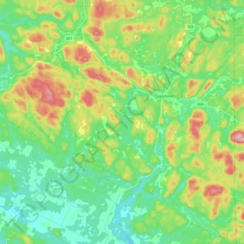
Name: Thorne topographic map, elevation, terrain.

Location: Thorne, Pontiac, Outaouais, Quebec, Canada (45.66935 -76.53725 45.82237 -76.32355)

Average elevation: 222 m

Minimum elevation: 157 m

Maximum elevation: 357 m

Other topographic maps

Click on a map to view its topography, its elevation and its terrain.

Sand Bay

Canada > Quebec > Pontiac > Clarendon

Average elevation: 85 m

Shawville

Canada > Quebec > Pontiac

Average elevation: 170 m

Lac Rueckwald

Canada > Quebec > Pontiac > Thorne

Average elevation: 223 m

Lac Pomponne

Canada > Quebec > Pontiac > Lac-Nilgaut

Average elevation: 347 m

Lac d'Ours

Canada > Quebec > Pontiac > Litchfield

Average elevation: 239 m

Bristol Mines

Canada > Quebec > Pontiac > Bristol

Average elevation: 93 m

Greer Mount

Canada > Quebec > Pontiac > Thorne

Average elevation: 261 m

Davidson

Canada > Quebec > Pontiac

Average elevation: 112 m

Lac Bongard

Canada > Quebec > Pontiac > Rapides-des-Joachims

Average elevation: 321 m

Lac a la Truite

Canada > Quebec > Pontiac > Sheenboro

Average elevation: 271 m

Danford Lake

Canada > Quebec > Pontiac > Alleyn-et-Cawood

Average elevation: 210 m

Gear up for your next adventure:

Camping Tent - Weather-resistant tents suitable for 2 to 6 people
💧Hydration Bladder - Hands-free hydration solution for long treks
🧼Travel Hand Sanitizer - Keep hands clean when water is scarce
🧥Thermal Fleece Jacket - Versatile insulation for changing mountain temperatures
💧Filtered Water Bottle - Safe drinking water on the go

As an Amazon Associate, this site earns from qualifying purchases at no extra cost to you.