Geolocate

Karlshamn topographic map

Click on the map to display elevation.

About this map

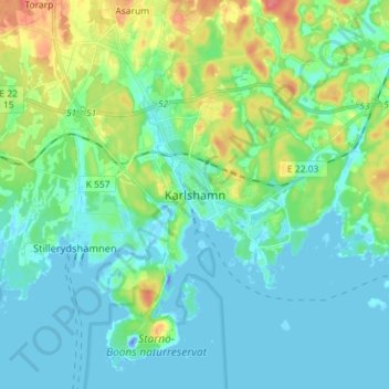
Name: Karlshamn topographic map, elevation, terrain.

Location: Karlshamn, Karlshamns kommun, Blekinge County, 374 36, Sweden (56.13017 14.82313 56.21017 14.90313)

Average elevation: 14 m

Minimum elevation: -31 m

Maximum elevation: 57 m

Other topographic maps

Click on a map to view its topography, its elevation and its terrain.

Sturkö

Sweden > Blekinge County > Sturkö

Average elevation: 4 m

Ronneby kommun

Sweden > Blekinge County

Average elevation: 45 m

Sölvesborgs kommun

Sweden > Blekinge County

Average elevation: 9 m

Gear up for your next adventure:

Lightweight Camping Tent - Portable shelter optimized for Canadian backcountry camping
🥾Hiking Shorts - Breathable shorts suitable for summer hikes
🧣Evaporative Cooling Towel - Beat the heat during intense summer climbs
🔦LED Headtorch - Bright and durable light for night activities
🧥Waterproof Jacket - Lightweight rain jackets for hiking and outdoor activities

As an Amazon Associate, this site earns from qualifying purchases at no extra cost to you.