Geolocate

Collahuasi topographic map

Click on the map to display elevation.

About this map

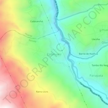
Name: Collahuasi topographic map, elevation, terrain.

Location: Collahuasi, Recuay, Province of Recuay, Ancash, Peru (-9.69124 -77.50608 -9.65124 -77.46608)

Average elevation: 3,623 m

Minimum elevation: 3,257 m

Maximum elevation: 4,237 m

Gear up for your next adventure:

🥾Light Trekking Boots - Supportive boots for multi-day treks
🧰Survival Kit - Essential gear for emergencies in the wilderness
🧴Bear Spray Holster - Quick-access carry for essential Canadian wilderness safety
🧭GPS Outdoor Watch - Smart watch for navigation and fitness tracking in nature
🌡️Emergency Mylar Blankets - Compact thermal protection for unexpected nights outdoors

As an Amazon Associate, this site earns from qualifying purchases at no extra cost to you.