Geolocate

Centre Point topographic map

Click on the map to display elevation.

About this map

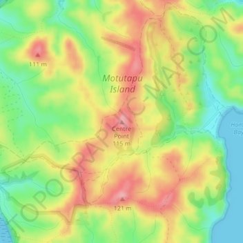
Name: Centre Point topographic map, elevation, terrain.

Location: Centre Point, Waiheke, Auckland, New Zealand (-36.76769 174.91539 -36.76759 174.91549)

Average elevation: 59 m

Minimum elevation: 0 m

Maximum elevation: 119 m

Other topographic maps

Click on a map to view its topography, its elevation and its terrain.

Waiheke Island

New Zealand > Auckland > Waiheke

Average elevation: 16 m

Motutapu Island

New Zealand > Auckland > Waiheke

Average elevation: 18 m

Pakatoa Island

New Zealand > Auckland > Waiheke

Average elevation: 1 m

Rangitoto Island

New Zealand > Auckland > Waiheke

Average elevation: 30 m

Motuihe Island

New Zealand > Auckland > Waiheke

Average elevation: 5 m

Waiheke Island

New Zealand > Auckland > Waiheke

Average elevation: 16 m

Motuihe Island

New Zealand > Auckland > Waiheke

Average elevation: 5 m

Ponui Island

New Zealand > Auckland > Waiheke

Average elevation: 15 m

Rangitoto Island

New Zealand > Auckland > Waiheke

Average elevation: 30 m

Sandy Bay Island

New Zealand > Auckland > Waiheke

Average elevation: 5 m

Gear up for your next adventure:

🧴Waterproofing Spray - Restore the DWR coating on jackets and tents
🥾Durable Hiking Shoes - Long-lasting shoes for frequent hiking
Camping Tent - Weather-resistant tents suitable for 2 to 6 people
🧢Beanie Hat - Keep your head warm in cold weather
🥾Trekking Poles - Adjustable trekking poles to reduce knee stress and improve stability

As an Amazon Associate, this site earns from qualifying purchases at no extra cost to you.