Geolocate

Motuihe Island topographic map

Click on the map to display elevation.

About this map

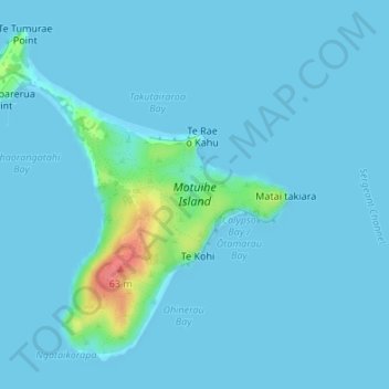
Name: Motuihe Island topographic map, elevation, terrain.

Location: Motuihe Island, Waiheke, Auckland, New Zealand (-36.82279 174.93303 -36.79953 174.95948)

Average elevation: 5 m

Minimum elevation: 0 m

Maximum elevation: 65 m

Other topographic maps

Click on a map to view its topography, its elevation and its terrain.

Centre Point

New Zealand > Auckland > Waiheke

Average elevation: 59 m

Gear up for your next adventure:

🧦Hiking Socks - Moisture-wicking and comfortable socks for long hikes
🦶Hiking Shoe Insoles - Added support for high arches and long days on feet
🧢Sun Protection Cap - Breathable cap to protect from sun exposure
🧰Survival Kit - Essential gear for emergencies in the wilderness
Backpacking Tent - Lightweight tent for long-distance hiking trips

As an Amazon Associate, this site earns from qualifying purchases at no extra cost to you.