Geolocate

Bellmore topographic map

Click on the map to display elevation.

About this map

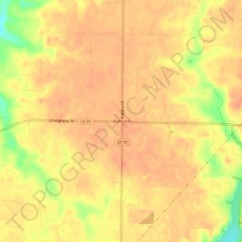
Name: Bellmore topographic map, elevation, terrain.

Location: Bellmore, Parke County, Indiana, United States (39.73921 -87.12529 39.77921 -87.08529)

Average elevation: 220 m

Minimum elevation: 186 m

Maximum elevation: 230 m

Other topographic maps

Click on a map to view its topography, its elevation and its terrain.

Rosedale

United States > Indiana > Parke County

Average elevation: 170 m

Bloomingdale

United States > Indiana > Parke County

Average elevation: 197 m

Mecca

United States > Indiana > Parke County

Average elevation: 180 m

Rocky Fork Lake

United States > Indiana > Parke County

Average elevation: 222 m

Montezuma

United States > Indiana > Parke County

Average elevation: 153 m

Case Lake

United States > Indiana > Parke County

Average elevation: 186 m

Gear up for your next adventure:

🧣Merino Neck Gaiter - Protects against wind, sun, and cold at high altitudes
🥾Trail Hiking Shoes - Durable shoes designed for rugged trails
🦟Insect Repellent - Keep mosquitoes and black flies away in wooded areas
Lightweight Camping Tent - Portable shelter optimized for Canadian backcountry camping
🧴Bear Spray Holster - Quick-access carry for essential Canadian wilderness safety

As an Amazon Associate, this site earns from qualifying purchases at no extra cost to you.