
Maui topographic map
Click on the map to display elevation.
Maui
Maui's diverse landscapes are the result of a unique combination of geology, topography, and climate. Each volcanic cone in the chain of the Hawaiian Islands is built of dark, iron-rich/quartz-poor rocks, which poured out of thousands of vents as highly fluid lava throughout millions of years. Several of the volcanoes were close enough to each other that lava flows on their flanks overlapped one another, merging into a single island. Maui is such a "volcanic doublet," formed from two shield volcanoes that overlapped one another to form an isthmus between them.
About this map
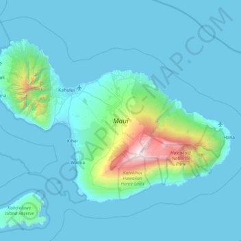
Name: Maui topographic map, elevation, terrain.
Location: Maui, Maui County, Hawaii, United States (20.57443 -156.69724 21.03156 -155.97909)
Average elevation: 232 m
Minimum elevation: -4 m
Maximum elevation: 3,044 m
Other topographic maps
Click on a map to view its topography, its elevation and its terrain.
Kula
United States > Hawaii > Maui County
Kula is a district and census-designated place (CDP) of Maui, Hawaii, that stretches across the "up-country", the western-facing slopes of Haleakalā, from Makawao to Kanaio. Most of the residential areas lie between about 500 to 1,100 m (1,600 to 3,600 ft) in elevation. The district has traditionally been…
Average elevation: 740 m
Haleakalā Observatories
United States > Hawaii > Maui County
The Haleakalā Observatory, also known as the Haleakalā High Altitude Observatory Site, is Hawaii's first astronomical research observatory. It is located on the island of Maui and is owned by the Institute for Astronomy of the University of Hawaiʻi, which operates some of the facilities on the site and…
Average elevation: 2,811 m
Kula
United States > Hawaii > Maui County
Kula is a census-designated place (CDP) of Maui, Hawaii. It stretches across Upcountry Maui, the western-facing slopes of Haleakalā. Most residential areas lie between about 500 to 1,100 m (1,600 to 3,600 ft) in elevation. The district is distinct from the generally hotter and busier coastal areas. The…
Average elevation: 740 m
Molokini Shoal Marine Life Conservation District
United States > Hawaii > Maui County
Average elevation: 0 m